
Magnificent fort in Rajasthan
Bundi Fort – Bundi Taragarh Fort or ‘Star Fort’ is the most impressive of structures of city of Ajmer in Indian state of Rajasthan. A rather ramshackle fort, with its overgrown vegetation, It was constructed in 1354 upon a steep hillside. There are three gateways to the fort, well known as Lakshmi Pol, Phuta Darwaza and Gagudi ki Phatak. Most parts of these impressive gateways are now in ruins. During its heyday, Taragarh Fort was renowned for its tunnels crisscrossing the entire hillside. However, these tunnels are now inaccessible for want of proper maps. The largest of its battlements is the 16th century bastion known as the Bhim Burj, on which was once mounted a particularly large cannon called Garbh Gunjam, or ‘Thunder from the Womb’. This erstwhile Chauhan bastion has some huge water reservoirs. These reservoirs were built to store water and supply it to the residents during time of crisis. The reservoirs have been carved out of the rocky base of the fort. Rani Mahal is a small palace within the fort complex, built for the wives and concubines of rulers. The Mahal has, however lost most of its charm as the shine of its spectacular murals and stained glass windows have completely faded away. The fort also has Miran Saheb ki Dargah. He was the governor of the fort and laid down his life in an encounter, in 1210.
BhanGarh fort Alwar– The Bhangarh Fort is a 17th-century fort built in the Rajasthan state of India. It was built by Man Singh I (one of the navratnas of Akbar’s court) for his younger brother Madho Singh I. It was named by Madho Singh after his grandfather Man Singh or Bhan Singh. The fort and its precincts are well preserved
The Bhangarh Fort is located on the border of the Sariska Reserve in the Aravali range of hills in Alwar district of Rajasthan.The nearest village is Golakabaas. The fort is situated at the foot of the hills on sloping terrain. The ruins of the King’s palace are located on the lower slope of the hills; trees surround the pond area and a natural stream falls into the pond within the premises of the palace.
The fort is located 235 kilometres from Delhi and the approach to the entrance gate of the fort in the last 2 kilometres stretch of the road is an unpaved road.The fort is 32 km from Thana Ghazi.
There are two legends related to the history of the fort city, which is reported to be haunted, and no one is allowed to remain in the precincts of the fort at night, per a notice board put up by the Archaeological Survey of India at the entrance.One version of the legend is that a sadhu named Baba Balau Nath lived within the fort area. It was his injunction that any houses built in the precincts of the fort should not be taller than his house, and if the shadow of any such house fell on his house, it would result in destruction of the fort town.
In another version, N.K. Sinhai, the wizard who was adept in black magic, fell in love with Ratnavati, the princess of Bhangarh, who was very beautiful, and had suitors to marry her from many royal families of the country. One day the princess, at 18 years of age, went shopping with her friends and was buying Ittar (scent). The wizard saw this and replaced the scent with a love potion in order to ensnare the princess. He offered the potion to her so that she would take a liking to him and marry him. However, the princess saw through the wizard’s trickery, and when he offered her the bowl of potion, she threw it onto a big boulder nearby. As a result, the boulder started rolling down towards the wizard and crushed him. Before he died, he made a curse that Bhangarh would be destroyed soon and no one would be able to live within its precincts. Subsequently, Bhangarh Fort was invaded by the Mughals from the north and the city was surrounded and sacked; 10,000 people lived in the fort city at that time. All the people in the fort, including the princess, were killed. The present state of the fort is attributed to the curse of the wizard and people believe the ghosts in the fort are those of the princess and the wizard.
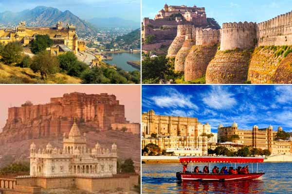
Amber Fort Jaipur – Amer Fort -Amber Fort is a fort located in Amer, Rajasthan, India. Amer is a town with an area of 4 square kilometres located 11 kilometres from Jaipur, the capital of Rajasthan. Located high on a hill, it is the principal tourist attraction in the Jaipur area. The town of Amer was originally built by Meenas, and later it was ruled by Raja Man Singh I (December 21, 1550 – July 6, 1614).
Amer Fort is known for its artistic Hindu style elements. With its large ramparts and series of gates and cobbled paths, the fort overlooks Maota Lake, which is the main source of water for the Amer Palace.
Constructed of red sandstone and marble, the attractive, opulent palace is laid out on four levels, each with a courtyard. It consists of the Diwan-i-Aam, or “Hall of Public Audience”, the Diwan-i-Khas, or “Hall of Private Audience”, the Sheesh Mahal (mirror palace), or Jai Mandir, and the Sukh Niwas where a cool climate is artificially created by winds that blow over a water cascade within the palace. Hence, the Amer Fort is also popularly known as the Amer Palace.[5] The palace was the residence of the Rajput Maharajas and their families. At the entrance to the palace near the fort’s Ganesh Gate, there is a temple dedicated to Shila Devi, a goddess of the Chaitanya cult, which was given to Raja Man Singh when he defeated the Raja of Jessore, Bengal in 1604.
This palace, along with Jaigarh Fort, is located immediately above on the Cheel ka Teela (Hill of Eagles) of the same Aravalli range of hills. The palace and Jaigarh Fort are considered one complex, as the two are connected by a subterranean passage. This passage was meant as an escape route in times of war to enable the royal family members and others in the Amer Fort to shift to the more redoubtable Jaigarh Fort.
Mehrangarh Fort Jodhpur – Rao Jodha, the chief of the Rathore clan, is credited with the origin of Jodhpur in India. He founded Jodhpur in 1459 (Jodhpur was previously known as Marwar). He was one of Ranmal’s 24 sons and became the fifteenth Rathore ruler. One year after his accession to the throne, Jodha decided to move his capital to the safer location of Jodhpur, as the one thousand years old Mandore fort was no longer considered to provide sufficient security.
With the trusted aid of Rao Nara (son of Rao Samra), the Mewar forces were subdued at Mandore. With that, Rao Jodha gave Rao Nara the title of Diwan. With the help of Rao Nara, the foundation of the fort was laid on 12 May 1459 by Jodha on a rocky hill 9 kilometres to the south of Mandore. This hill was known as Bhakurcheeria, the mountain of birds. According to legend to build the fort he had to displace the hill’s sole human occupant, a hermit called Cheeria Nathji, the lord of birds. Upset at being forced to move Cheeria Nathji cursed Rao Jodha with “Jodha! May your citadel ever suffer a scarcity of water!”. Rao Jodha managed to appease the hermit by building a house and a temple in the fort very near the cave the hermit had used for meditation, though only to the extent that even today the area is plagued by a drought every 3 to 4 years. Jodha then took an extreme measure to ensure that the new site proved propitious; he buried a man called “Raja Ram Meghwal” alive in the foundations. “Raja Ram Meghwal” was promised that in return his family would be looked after by the Rathores. To this day his descendants still live in Raj Bagh, “Raja Ram Meghwal’s” Garden, an estate bequeathed them by Jodha.
Rao Jodha then invited the famous female hindu warrior sage of Charan caste, Shri Karni Mata, to lay down the foundation stone of the Mehrangarh Fort and the same was carried out by her. Today only the forts of Bikaner and Jodhpur remain in the hands of Rathors, both had their foundation stone laid by Shri Karni Mata. All other Rajput forts of Rajasthan were abandoned for some or the other reasons by the respective clans. Only the Rathors of Jodhpur and Bikaner have their forts with them till date. This fact is considered a miracle by the local population and is attributed to Shri Karni Mata.
Rao Jodha also granted villages of Mathania and Chopasni to the two Charan warlords who were sent by him to request Shri Karni Mata to come to Jodhpur.
Jaisalmer Fort –Jaisalmer Fort is one of the largest fully preserved fortified cities in the world. It is situated in the city of Jaisalmer, in the Indian state of Rajasthan. It is a World Heritage Site. It was built in 1156 AD by the Rajput Rawal (ruler) Jaisal, from whom it derives its name. The fort stands amidst the sandy expanse of the great Thar Desert, on Trikuta Hill. Before the days of the British Raj, the fortress city served as a refuge and way-station for caravans and travelers along the Silk Road. Its ramparts served as the backdrop for many battles in past centuries when the Silk Road still served as one of the main trade routes between East and West.the fort’s massive yellow sandstone walls are a tawny lion colour during the day, fading to honey-gold as the sun sets, thereby camouflaging the fort in the yellow desert. For this reason, it is also known as the Sonar Quila or Golden Fort. The fort is located along the southern edge of the city that bears its name, and is perhaps one of the more striking monuments in the area, its dominant hilltop location making the sprawling towers of its fortifications visible for many miles around.
Ranthambhore fort -Ranthambore Fort lies within the Ranthambore National Park, near the town of Sawai Madhopur, the park being the former hunting grounds of the Maharajahs of Jaipur until the time of India’s Independence. It is a formidable fort having been a focal point of the historical developments of Rajasthan. The fort is known for the glory and valor of Hammir dev of the Chauhan dynasty.
The Ranthambore fort was built by a Chauhan Rajput ruler, although the exact name of the ruler is disputed. A widely held belief states that the fort was built the reign of Sapaldaksha, in 944 CE. Another theory states that the fort was built during the reign of Jayant, in 1110 CE. According to Government of Rajasthan’s Amber Development & Management Authority, it is likely that the construction started in the mid-10th century during the reign of Sapaldaksha, and continued a few centuries after that.
Chittorgarh Fort-The Chittor Fort or Chittorgarh is one of the largest forts in India. It is a UNESCO World Heritage Site. The fort was the capital of Mewar and is today situated in the Chittorgarh town. It sprawls over a hill 180 m in height spread over an area of 280 ha above the plains of the valley drained by the Berach River. The fort precinct has several historical palaces, gates, temples and two prominent commemoration towers. These monumental ruins have inspired the imagination of tourists and writers for centuries.
From 7th century, the fort was ruled by the Mewar Kingdom. In 1303, the Turkic ruler of Delhi, Alauddin Khalji defeated Rana Ratan Singh, in 1535 Bahadur Shah, the Sultan of Gujarat defeated Bikramjeet Singh and in 1567 Akbar defeated Maharana Udai Singh II who later founded Udaipur. Each time the men fought bravely rushing out of the fort walls charging the enemy but lost every time. Following these defeats, the women are said to have committed Jauhar or mass self-immolation. Thus, the fort represents the quintessence of tribute to the nationalism, courage, medieval chivalry and sacrifice exhibited by the Mewar rulers of Sisodia and their kinsmen and women and children, between the 7th and 16th centuries. The rulers, their soldiers, the women folk of royalty and the commoners considered death as a better option than dishonor in the face of surrender to the foreign invading armies.
Kumbhalgarh fort – Kumbhalgarh (“Kumbhal fort“) is a Mewar fortress on the westerly range of Aravalli Hills, in the Rajsamand district near Udaipur of Rajasthan state in western India. It is a World Heritage Site included in Hill Forts of Rajasthan. Built during the course of the 15th century by Rana Kumbha, Kumbhalgarh is also the birthplace of Maharana Pratap, the great king and warrior of Mewar. Occupied until the late 19th century, the fort is now open to the public and is spectacularly lit for a few minutes each evening. Kumbalgarh is situated 82 km northwest of Udaipur by road. It is the most important fort in Mewar after Chittaurgarh. With a wall over 38 km long, the fort is among the largest wall complex in the world, and the second largest fort in Rajasthan after Chittor Fort.